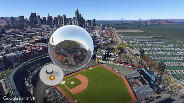
Today Google has launched an update to Google Earth VR which brings the company’s huge library of street-level imagery into the application which lets users immersively explore the entire globe.
Google Earth VR is a stunning VR experience which we called “a breathtaking new way to know our planet,” back when it launched in late 2016. Now the application, which is available on both the HTC Vive and Oculus Rift, is getting even better thanks to the addition of Street View browsing.
Google Earth VR lets you fly from an overview of the entire Earth right down to a block-scale view, letting you see actual geometry of buildings and more (in places where available), but when you zoom all the way down to human-scale, that geometry isn’t particularly precise. Now with the latest update to Google Earth VR you can flip to Street View imagery, which lets you see actual street-level photos captured by Google’s fleet of Street View cameras in 85 countries. In addition to Google-captured imagery, you’ll also be able to see 360 geo-tagged photos captured by users (same as you can see on Google Maps).
In Google Earth VR when you zoom down near street-level you’ll be able to see a floating photosphere above your controller if Street View imagery is available for that region. Just hold the sphere up to your head to dive into the closeup view. It’s a cool new feature, but we’ve still got our fingers crossed for multi-user support for cooperative exploration.
Google Earth VR is free for both the HTC Vive and Oculus Rift, and if you have neither of those systems, you can immersively view Street View imagery through the Street View app on Daydream (Android) or Cardboard (Android & iPhone).


